Presentation: Professor Francisco Salamanca Palou at the MPAS/WRF Workshop

Francisco Salamanca Palou, Assistant Research Professor, School of Mathematical and Statistical Sciences, June 10, 2019, presented “Summer and Wintertime Variations of the Surface and Near-surface UHI in a Semiarid Environment” to a joint MPAS/WRF workshop. Prepared by both Salamanca & colleague Alex Mahalov, Dean’s Distinguished Professor from the same school, Salamanca explained the motivation for this work stems from recent work done to augment the WRF-urban modeling system. Realizing that there was still additional work to complete, Salamanca and Mahalov set out to “examine summer- and wintertime variations of the surface and near-surface UHI for a semiarid urban environment using MODIS and near-surface meteorological observations.” Also, “to evaluate the WRF-urban modeling system’s (coupled to Noah-MP LSM) ability to reproduce the diurnal cycle of near-surface meteorology and LST during Salamanca News July
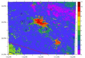
both summer and wintertime weather conditions.”


Sharing detailed modeling experiments, the author’s conclusions were:

  1. The Surface UHI is found to be higher at night and during the warm season.
  2. The morning Surface UHI is low and frequently exhibits an Urban Cool Island that increases during the summertime period.
  3. The Near-surface UHI is higher at night and during summertime.
  4. The morning Near-surface UHI is low but rarely exhibits an Urban Cool Island.
  5. WRF (coupled to Noah-MP) model tends to slightly underestimate surface skin temperature during daytime but overestimates nighttime values during wintertime.
  6. WRF (coupled to Noah-MP) model tends to accurately reproduce the diurnal cycle of near-surface air temperature and wind speed during summertime, but overestimate near-surface nighttime air temperature during wintertime.

The entire presentation is available at: http://www2.mmm.ucar.edu/wrf/users/workshops/WS2019/workshop19agenda.php

Research Update: Lance Watkins

UCRC Director, Dr. David Sailor presenting Lance Watkins his 1st place, Graduate Category, for the 2019 UCRC Poster Competition
UCRC Director, Dr. David Sailor presenting Lance Watkins his 1st place, Graduate Category, for the 2019 UCRC Poster Competition.

Moving research along in the heat of the summer, Lance Watkins, 1st place winner of the spring 2019 UCRC poster competition (graduate student category), recently shared some of his updated findings. Lance is a PhD student with the School of Geographical Sciences and Urban Planning. His research focuses on extreme heat, urban climate, and utilizing geographical information science in decision-making.
Lance’s poster titled “Comparison of Two Vulnerability Indices to Household Experience with Extreme Heat in Phoenix, Arizona, posed the following questions.

1: To what extent do measures of vulnerability based on aggregate demographic indicators correlate with measures of vulnerability based on variables at the household level?

2: Which measure of vulnerability based on aggregate demographic indicators correlates more closely with measures of vulnerability based on variables at the household level, one based on an all-hazards model, or one that is hazard specific?

In between chasing early summer storms, Lance shared the following:

We found strong relationships between several of these variables and the Heat Vulnerability Index (HVI). Households in highly vulnerable census tracts as defined by HVI were less likely to have and use central AC, less likely to have immediate access to cooler outdoor environments, more likely to use alternative cooling strategies such as window AC units and window fans, and more likely to experience heat illness requiring medical attention. The Social Vulnerability Index (SoVI) was associated with fewer survey variables. As defined by SoVI, households in more vulnerable areas in our sample were less likely to live in structurally cooler environments (e.g., limited access to basements and yards with grass), more likely to be of poorer health status, and more likely to have their home cooling be limited by the cost of repairing central AC. The differences between the two indices’ relationships with household scale variables underscores the importance of specifying the hazard of relevance when conducting a vulnerability or risk assessment.
In addition, our results suggest that, while aggregate-level vulnerability indices can help prioritize certain communities for intervention measures and future investments in structural changes in the social and built environments of cities, more precise data from households are valuable to inform the types of interventions and investments that can address the causal drivers of such vulnerability.

Lance intends to submit these findings to the journal of Applied Geography in the coming weeks.