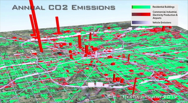
View Source | October 10, 2012
 Arizona State University researchers have developed a new software system capable of estimating greenhouse gas emissions across entire urban landscapes, all the way down to roads and individual buildings. Until now, scientists quantified carbon dioxide (CO2) emissions at a much broader level.
Dubbed “Hestia” after the Greek goddess of the hearth and home, researchers presented the new system in an article published Oct. 9 in Environmental Science and Technology. Hestia combines extensive public database “data-mining” with traffic simulation and building-by-building energy-consumption modeling. Its high-resolution maps clearly identify CO2 emission sources in a way that policymakers can utilize and the public can understand.
“Cities have had little information with which to guide reductions in greenhouse gas emissions – and you can’t reduce what you can’t measure,” said Kevin Gurney, an associate professor in ASU’s School of Life Sciences, and senior scientist with the Global Institute of Sustainability. “With Hestia, we can provide cities with a complete, three-dimensional picture of where, when and how carbon dioxide emissions are occurring.”

