View Source | September 11, 2014
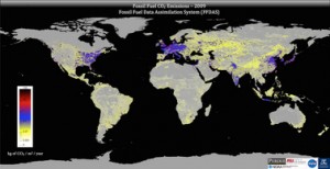
 An international research team, led by sustainability scientist Kevin Gurney, has developed a new approach to estimating CO2 emissions from burning fossil fuels. Called the “Fossil Fuel Data Assimilation System,” or FFDAS, this new system was used to quantify 15 years of CO2 emissions, every hour, for the entire planet – down to the city scale. Until now, scientists have estimated greenhouse gas emissions using less reliable techniques.
The FFDAS uses information from satellite feeds, national fuel accounts and a new global database on power plants to create high-resolution planetary maps. These maps provide a scientific, independent assessment of the planet’s greenhouse gas emissions. They represent an approach that the public can understand and that policymakers - who face multiple barriers in their efforts to address greenhouse gas emissions - can use.
“With this system, we are taking a big step toward creating a global monitoring system for greenhouse gases, something that is needed as the world considers how best to meet greenhouse gas reductions,” said Gurney. “Now we can provide all countries with detailed information about their CO2 emissions and show that independent, scientific monitoring of greenhouse gases is possible.”

