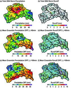
Figure 10. Spatial distribution of total (a) rainfall and (b) runoff at LTHOM during Storm 2004, 2 using QPE forcing; mean ensemble difference of precipitation for (c) 60-min and (e) 180-min 3 lead times; and mean ensemble differences of runoff for (d) 60-min and (f) 180-min lead times.Flood forecasting in mountain basins remains a challenge given the difficulty in accurately predicting rainfall and in representing hydrologic processes in complex terrain. This study identifies flood predictability patterns in mountain areas using quantitative precipitation forecasts for two summer events from radar nowcasting and a distributed hydrologic model. We focus on eleven mountain watersheds in the Colorado Front Range (CFR) for two warm-season convective periods in 2004 and 2006. The effects of rainfall distribution, forecast lead time and basin area on flood forecasting skill are quantified by means of regional verification of precipitation fields and analyses of the integrated and distributed basin responses. We postulate that rainfall and watershed characteristics are responsible for patterns that determine flood predictability at different catchment scales. Coupled simulations reveal that the largest decrease in precipitation forecast skill occurs between 15 and 45-min lead times that coincide with rapid development and movements of convective systems. Consistent with this, flood forecasting skill decreases with nowcasting lead time, but the functional relation depends on the interactions between watershed properties and rainfall characteristics. Across the majority of the basins, flood forecasting skill is reduced noticeably for nowcasting lead times greater than 30-min. We identified that intermediate basin areas (~2 to 20 km2) exhibit the largest flood forecast errors with the largest differences across nowcasting ensemble members. The typical size of summer convective storms is found to coincide well with these maximum errors, while basin properties dictate the shape of the scale dependency of flood predictability for different lead times.
(1) School of Sustainable Engineering and the Built Environment, Arizona State University, Tempe, AZ 85287
(2) Decision Center for a Desert City, Global Institute of Sustainability, Arizona State University, Tempe, AZ 85287
(3) School of Earth and Space Exploration, Arizona State University, Tempe, AZ 85287
(4) National Center for Atmospheric Research, Boulder, CO